In April, 2019 I took 5 Grand Canyon hikes on trails which Jerry Forster and I had taken over the course of our 17 trips.
- South Kaibab to the river
- Bright Angel back to the rim
- Tanner day hike
- Grandview day hike
- Hermit day hike
To get the best format of the photos, click on the first one and it will fill the screen, then click on the second mini-photo at the bottom of the screen. You may click through all the photos in this manner. You won't get my captions but, the pictures are better in the larger format.
 |
| We always managed to get to the rim before sunset whether we flew into Phoenix or Las Vegas, whether the South Rim or the North Rim. I had dinner at the Bright Angel Restaurant as we always did, then stopped in at Babbits for last minute supplies. |
South Kaibab Trail
 |
| We hiked down South Kiabab 3 times and hiked up once. When Jerry took his daughters, Amy and Nancy, they went down this trail. That is Jerry's hat perched on the sign. |
 |
| Every day Jerry ate a Cliff Bar with his oatmeal, and every day we shared an orange. If we ate one that he carried, he would share 40% and vice versa. We never discussed it. It's just how it always worked out. |
 |
| Cedar Ridge is the first natural rest spot on the S. Kaibab trail. There is a rest room and the mule parties stop here. Jerry never liked to hang around. Too many people. |
 |
| Looking out from Cedar Ridge towards O'Neil Butte. Note the switchbacks falling off to the right. |
 |
| Skeleton Point is where those switchbacks begin. |
 |
| A little closer look at the switchbacks. Many of the lines in the trail mark step downs of about 15 inches. |
 |
| I was a few weeks earlier than our normal dates. There were very few flowers in bloom. |
 |
| The Tipoff is where the trail leaves the sort of level Tonto Platform and begins the seemingly endless descent into the inner gorge. |
 |
| The trail winds down the canyon wall until you can finally see the bridge over the Colorado River. |
 |
| At the same moment, if you look to the left, you can also see the climb from Bright Angel Campground, among the trees, up to Piano Alley. At this point, you are below Piano Alley in elevation. I'm guessing that Jerry did not point all that out to Amy and Nancy at this moment. |
 |
| We always had more hiking to do when we had arrived at the Bright Angel Campground, but we found a shady spot for lunch, a nap, and soaked our feet in Bright Angel Creek. |
 |
| Following our nap, we would wander over to Phantom Ranch and get a glass of the best lemonade in the world. Now days it is $4.50 for the first glass but only $1.00 for refills. Seems like a great deal when you've hiked down to get there. We once had the hiker stew dinner at Phantom. This year I lucked into a steak dinner, a bunk, breakfast and a packed lunch. |
Bright Angel Trail
 |
| After eating at the early sitting for breakfast, I was walking by 5:22. I was able to put my headlamp away when I reached the river. |
 |
| We hiked up the Bright Angel trail twice. It is the trail that Jan and Trina hiked up when they did the raft trip with us in 1993. Amy and Nancy also hiked up the Bright Angel with Jerry and John. This is the point where the trail leaves the river and the real hike begins. This is where the rafts dropped us off in '93. |
 |
| Looking up toward the South Rim. |
 |
| After an hour or two, looking back down toward the river and the north rim. |
 |
| Entering Tapeats narrows, our favorite part of the Bright Angel Trail. We always made it here before the sun was overhead. There is a bubbling brook and all the life that water brings in the desert. |
 |
| A very tempting place to take a break but there are benches up ahead. |
 |
| Indian Garden, half way. Shade, benches, running water, toilets. I don't think we were ever here when the temperature was below 80 degrees though. |
 |
| After leaving Indian Garden you are faced with this view. The normal question is, "How are we going to get up that?" |
 |
| The answer to that How question. If you study this photo, you will see 5 switchbacks. This is only the beginning. |
 |
| Looking toward the North Rim from above Indian Garden. |
 |
| 3 mile house; 3 miles from the rim. 8 miles from Phantom Ranch. Jerry might let us take a break here depending on how many people were here at the time. |
 |
| I omitted a picture of Mile and a Half house. Jerry never wanted to stop there, due to all the day hikers that are inevitably there. There are two tunnels. When you reach the first one, you are getting close to the rim. |
 |
| When you reach the second tunnel, you are almost done. I was walking with a ranger when I reached this point. The subject of the memorial hike came up. She asked if it was bringing back memories. I said, "Not enough." |
 |
| We are officially back at the rim. Time to clean up at the campground showers and drive into Flagstaff for a great salad and a Sizzler steak. (This year I postponed that part of the tradition for a few days since I had three more hikes.) |
Tanner Trail
 |
| Tanner was the first trail Jerry and I descended in 1991. You can read more about it in the first chapter of Best Stories, available on this blog. This year it was snowy up on the rim, but the snow was not "sticking" on the trail, so I started the hike as planned. |
 |
| I kept my eye on the weather over the canyon. |
 |
| There is a saddle of rock with large rocks perched on top, like the back of a stegosaurus. At this point I checked up behind me to see if I could now see the rim. The snow had almost stopped, so I continued the hike. |
 |
| Looking down, through the Stegosaurus Rocks you can see down into 75 Mile Canyon. On our hikes of this area, we always reached the other end of 75 Mile Canyon, at the river, in a few days. |
 |
| I turned around at this point. It overlooks the point at which the trail falls off the right side of the mesa and starts the steepest, loosest descent of the Red Wall Limestone that we ever did. (And we did it four times.) It also over looks a bit of the Colorado where we had camped four nights as we hiked along the buttes to the Little Colorado River. |
 |
| Near the Rim, looking out on the day's hike. |
 |
| Done for the day. Back on the rim. |
 |
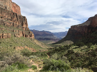
| The next few photos are taken from the Dessert View Tower which is about mile from the Tanner trail head. This photo shows the two bowls that the trail winds through and the turn around point which is a bit right of center. |
 |
| Jerry and John and I hiked all the way down to the river, at a point just across from the large volcanic, black rock wall. Twice we subsequently hiked up the river another 10 miles. |
Grandview Trail
 |
| On our first Grand Canyon adventure we came back out to the South Rim via the Grand View Trail. We also came out this way in 2011, our last trip in this area. |
 |
| The trail switch backs down the face of the cliffs for an hour or so until suddenly you get this view framed between the canyon wall on the right and the butte on the left. You get a clear understanding of how much rock you have come down. |
 |
| On our first trip, we camped on Horseshoe Mesa with John and Matt Leonard, who had met us down on the Colorado. We had come up from Hance Creek and had refilled our water bottles at Page Springs. |
 |
| There were active mines on the mesa early in the last century. There are many artifacts such as the stone building in the center of the picture. |
 |
| The view from a particularly nicely appointed camp site. Such a bench is quite a luxury in the back country. |
 |
| This photo shows how steep and high the Red Wall Limestone is. It can only be climbed or descended where there are geologic faults, in only a few places in the Canyon. |
 |
| Looking across the abyss to the faint trail which hugs the edge. Jerry said this kind of trail got his adrenaline pumping. |
 |
| The composting toilets are inside the wooden enclosures. Not a lot of privacy but a great view from the seats. |
 |
| Jerry was the very best at finding shade in the desert for breaks. He would have liked these spots. |
 |
| Grand View has thousands of stones carefully placed to keep the trail from eroding away. The pictures never reveal how steep it really is. |
 |
| Looking back down to Horsheshoe Mesa and toward the North Rim. The trail works its way down the slope in the right side of the photo. |
 |
| Back to the trail head on the South Rim. |
Hermit Trail
 |
| The Hermit Trail was our second adventure and we repeated it with John Leonard in 2000. |
 |
| The Boucher Trail forks off the Hermit in the valley in the left of this photo. It winds across the face of the butte in the center, and on one occasion we hiked back into the bowl on the right of the photo to enjoy the Hermit Spring. On two other occasions we proceeded along the Boucher Trail about 8 miles. |
 |
| A shady spot with smooth, horizontal "furniture" on which to rest. We probably rested here. |
 |
| The trail junction noted above. |
 |
| My turn around point on the Hermit Trail, looking down on the Hermit camp in the innermost gorge, and if you can locate the bit of white water, the Hermit Rapid. |
 |
| There is also the Santa Maria spring right on the Hermit Trail. Next to the spring is a shady, cool stone shelter. I believe the bench was there in 1992, but who brought the rocking chair down? |
 |
| Is that rain across the river? |
 |
| After a few minutes of light rain, it switched to heavy snow, but only for 10 minutes. |
 |
| Back to the trail head on the rim. |
 |
| The Cliff bar is eaten. The last orange is gone... |


No comments:
Post a Comment