May 18 – 26, 2010
Resources
- Utah’s Incredible Backcountry Trails by David Day, Rincon Publishing, Orem UT
- Canyonlands National Park Favorite Jeep Roads & Hiking Trails by David Day, Rincon Publishing, Orem UT
- Needles District Trails Illustrated Map, National Geographic
- NPS Website - http://www.nps.gov/cany/index.htm
- NPS Map - http://www.nps.gov/cany/planyourvisit/upload/tripmap.pdf

Fly and Drive to Canyonlands – Flew to Denver. This meant more miles to drive but due to flight schedules, it meant we could arrive at Cayonlands over an hour sooner. Flight was only about 30% full out of Detroit and only about 60% full out of Chicago. By the time Jerry and Norm got to baggage claim, John already had all the bags gathered up. Luckily, Norm caught the bag of hiking sticks disappearing in the ski carousel out of the corner of his eye. Fortunately for us, Alamo allowed us to select a nice big Chrysler mini-van for the price of a full sized car. This made it so much easier to get stuff in and out of our packs when in camp. Renting the car through Costco gave us a 15% discount but much more valuable, it gave us a second driver free, saving us about 200 dollars. We arrived in Moab by mid afternoon so we had an early supper (Pasta Jay’s), bought butane (Gear Heads), and bottled water. Then there was still about 80 miles to go to get to the actual national park. We stayed at the private camp ground just outside the park, Needles Outpost. We had a reservation and they had a site literally with our name on it. We slept under the stars.
Campsite EC1, Chesler Park and the Joint Trail – We got our actual permit at the visitor’s center. The system at Canyonlands is you get a reservation for your campsites and use areas but you do not get your actual permit in the mail, like you do at the Grand Canyon. You get your permit at the visitor center before starting your hike. We parked the car at the Elephant Hill parking lot. We planned to hike out to EC1 and leave our packs, and then hike unencumbered around Chesler Park. We would hike on to the Colorado the next day, so we had to carry an extra gallon of water over those first few miles to EC1.
We reached EC1, dropped our packs, hung our food, made up day packs and were hiking again by 11:00. Between the parking lot and Chesler Park, there are many ups and downs. It was nice to do some of it without the packs. We enjoyed seeing and pointing out all the various shapes of sandstone which look like something, animals or people. To get to Chesler Park, go until you are at King Kong’s foot and turn left to go up and over. Jerry saw aliens everywhere, every day.
Once in Chesler Park we followed the signs to the Joint Trail. As we descended, three young ladies told us that people go in but no one comes out. Sounded ominous. The Joint Trail; what fun. So narrow, and it gets deeper and deeper.
 At the West end we enjoyed Cairn Temple. More cairns in one place than we’ve ever seen. Taller and more elaborate. They actually confuse the route a bit. When you get to Cairn Temple make a 90 degree turn (right if you’re going west. Left if you’re going east).
 After the Joint Trail we followed the signs towards Druid Arch, watching the map. The signs at trail intersections in Cayonlands are the best we have experienced in our 20 years of hiking; clear, consicse with distances. The trail descends into a water shed which leads out to Druid Arch. We had planned to make DA optional, so we talked it over at that point. We decided we had enough day left and maybe enough energy but we did not have enough water, and no filter to clean the water near the Arch. We followed the water shed in the opposite direction and it took us right back to EC1. We were happy enough to be done for the day and found shade in which to rest before dinner. Slept under the stars.


EC1 to the Colorado River – The plan was to hike through the Lower Red Canyon down to the Colorado River, then down the river to the Confluence with the Green, then to take a trail described in a book up to the rim and hike on jeep trails back to the car, a 3 day loop. We had to retrace some of yesterday’s steps but this time with full packs. Go to King Kong’s foot but turn right, not left. Follow the sign to Devil’s Kitchen, Jeep Camp. At one point we had to take our packs off and carry them as we were all bent over, to get under a very low spot. Since we had the packs off and it was shady, we took our first break there.


.jpg)
Upstream to the Confluence – Norm had been inspired, over 20 years ago, to visit Canyonlands, by the passage in J.W. Powell’s journal about reaching the confluence of the Green and the Colorado. He wanted to get to the actual confluence or at least to an overlook. This would be the day that goal would finally be achieved. The walk began on a clear, firm trail. Eventually the trail gets harder to follow in the overgrowth. It then gets braided, i.e. multiple parallel trails. We saw the jet boat picking up canoes and saw the warning sign about Cataract Canyon. As the trail reaches the actual confluence, it pretty much disappears. The rock falls extend all the way to the Tamies and the going gets more and more difficult and scratchier. Either crawl through the bushes or climb over the rocks. We tried both. At the confluence there is no break in the Tamies.

All the time we worked our way east, we were looking up the rock wall to find a trail which was supposed to take us to the “rim” the next day. This trail is clearly described and mapped in the Utah’s Incredible Backcountry Trails book noted above. The description was written for someone starting above and coming down to the river but it indicates the trail is well cairned even down near the river. We were looking to the right to find this trail for the next day and looking to the left to find a break in the Tamies so we could get water and camp that evening. The campsite we found was right at the base of a very steep watershed. Norm hoped this was the watershed with the trail. He climbed up a hundred feet or so but did not find any cairns. Even at 100 feet the watershed had cliffed out on the left and looked like it could easily cliff out on the right a little higher up. He climbed back down. We had lunch, got some fresh water, rested and then Norm and Jerry went back west, to find that trail up to the “rim”. We walked back to within a third of a mile of the confluence and found no cairns and no trail that we believed would be safe or climbable with packs. The book indicated that the foot of the mystery trail was .9 miles from the confluence, but we wanted to exhaust all possibilities. We returned to camp. That night we ate freeze dried shepherd’s pie from Backpacker’s Pantry. It was very spicy and only John wanted seconds. Norm and Jerry were happy to let him have as much as he wanted. At this point, Norm’s longtime aspiration to “get to the confluence” was looking pretty dismal; no trail up, lousy campsite, lousy dinner. Tramping through the underbrush resulted in dozens (seemed like hundreds) of seeds being lodged in our socks and boots. It literally required at least 30 minutes per foot to rid ourselves of these embedded seeds.
Now What? – John was optimistic that given different lighting and a good night’s rest we would find the trail noted in the book. Norm wasn’t so sure and started discussing the real possibility of backtracking the two days. We did not have a freeze dried dinner for the extra night but we had plenty of snacks. We decided that the energy and time required to climb the watershed right next to the camping spot was unlikely to get us to the rim and would just wear us down and delay the other options. We walked back west carefully examining every possible route up. John said it best when he said, “I haven’t seen anything that doesn’t scare me to death.” We could see many ways to get high above the beach but all seemed to cliff out at some point where it would be too steep to climb, even if we pulled the packs up with John’s rope. We searched the most diligently at .9 miles from the confluence, but no trail revealed itself. As we had just about reached the confluence we saw several cairns in a rock fall. Norm started to get optimistic. We had just such a moment in Merlin’s Abyss several years before. One minute things looked bleak and the next minute life was good again. We climbed high above the last cairn that we could see and the cairns just ran out. Even the ones we found did not lead to each other or define a trail. We reluctantly started back to our beach at the foot of Red Lake Canyon. Our objective was to reach the beach, refuel, fill up with fresh water, and then late in the day, climb the “stairs” back up over the 4th graben.
We reached the beach in good time. As we relaxed, people from a group of 25 trickled through our camp. They had started at Elephant Hill and come via the jeep roads. Their destination was Brown Betty Rapids. From there they would be transported via jet boat to a few more destinations. They all seemed very serious. We were little help regarding how to proceed down river. We suggested there must be a trail along the river just as there was one going up river. They left us and found various paths out of the watershed in search of their trail. None came back so we assume they found their trail.
We left camp at 5:30 and at 6:30 we had reached the bottom of the steps. The whole hour was walking in loose sand. It took another 1:15 hour to get to the top and back down to a level spot to camp. Since we had no freeze dried food, we didn’t fire up the stoves, but rather had tuna or chicken from envelopes.
Back to the Car – We climbed over the remaining grabens, took the jeep trail towards Devil’s Kitchen and then cut north on a one-way jeep trail.
 We found it hard to believe that vehicles could negotiate the rough terrain and exposed rocks on the jeep trails. We had a chance to watch several overcome the obstacles of a section about half a mile from the parking lot. Jerry thought it looked like fun. A Jeep had an inverted decal which said “If you can read this flip us over”. Norm said he liked it. The passenger said it used to be funny until they got onto these roads.

We encountered some rangers and explained that we had deviated from our plan and thus our permit because we could not find that trail at the confluence. They apologized that we had not been warned about that trail. They explained the importance of staying on the permits and the plans that make that possible. One said, “Based on your experience, if there had been a trail, you guys would have found it.” If anyone who reads this blog has taken a trail that runs from the confluence overlook in the Needles District directly down to the river, up or down, I would be most curious to hear more about the trail. Please comment. I have provided details from the book to the park service and have written to the publisher describing our experience. (I was feeling sort of intimidated since I knew J.W. Powell had climbed from the river with only one arm. He did it on the North side of the rivers though.)
We drove the car back to Needles Outpost by 12:30 and set up camp again. We enjoyed the traditional ice cream and soda, and hot showers. It was extremely windy, to the extent that we could not even see the nearby rock outcroppings. We set up the tents and Jerry slept in the van.
Salt Creek Canyon – Originally, Norm had planned a narrow loop requiring us to cross over from the main Salt Creek Canyon over into the west fork. We’d camp in the west fork and have a day out of our packs to explore up around Angel Arch, camping at SC3. Then on the third day, we’d hike south in the main creek. We were now a day short and had already had enough “off trail” hiking. We changed the plan to a simple “out and back”, camping at SC3 per our permit and then retracing our steps back to the car.
We moved the car to Cathedral Butte. The sign from the paved road does not say Cathedral Butte or Salt Creek Trail. It says Beef Basin, which is well past the trail head. The road quickly crosses a creek. We could not see the bottom of the creek and the flow was substantial. Jerry took off his shoes and waded across to ensure we would not get stuck. (The warning for the Jeeps says towing bills are often $1,000. That figure got our attention.) The road is dirt and was very rutted but we did not fear getting stuck again. We encountered a first for us. There is a fence that crosses (yes crosses) the road. At first we thought we would not be able to get to the trail head. As Norm pulled closer we read the sign on the fence, “Please close after passing”. John jumped out and opened and then closed the fence/gate behind us. The trail head is about 15 miles away from the paved road.
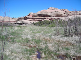
We were hiking by 9:30. It was very cool and we all started in long pants and sweat shirts. We didn’t need to drink as much or stop as often to rest. We hiked down for about an hour before it started to level off. After reaching the bottom we encountered something unusual, a marsh in the desert, complete with cat tails.
.jpg) We enjoyed looking at Kirk’s cabin but kept asking, “How did he get that buckboard down here?” And “How did he get supplies from Moab?”
We enjoyed looking at Kirk’s cabin but kept asking, “How did he get that buckboard down here?” And “How did he get supplies from Moab?”

.jpg)
The trail takes you about as close as is practical to each of the “sights” including
· Pictograph on the right
· Stream/Spring
· Kirk’s Cabin
· Kirk’s Fence
· Anasazi Ruin on the right.
Views of Kirk’s Arch on the left.

· Extensive Anasazi Ruin (Big Ruin) on the left. Getting close is a bit of chore. Getting back is even more of a challenge due to the braided trails. “Did we come this way?”

· Anasazi Ruin on the right.
· Wedding Ring Arch on the right.

· Anasazi Ruin on the left. This one has self seeding squash going all the way back to the original Anasazi squash.
· Fisheye arch on the right.
All American Man Pictograph with Anasazi Ruin on the right. It is hard to get a picture without climbing a little bit.
· Four Faces Pictograph on the right.
· Stream/Spring
· Camp SC3.
We found the description in the Canyonlands National Park Favorite Jeep Roads and Hiking Trails book to be extremely accurate and helpful.
We knew from the weather posting at the Visitor Center that it was going to get down to freezing that night. Norm carried his tent just for this occasion. Jerry wore every piece of clothing he brought and slept under the stars.
Back to the Car (again) –Jerry’s bottle had ice in it and Norm’s Camelback didn’t work because there was ice in the tube. We enjoyed our coffee and Oatmeal. We started hiking at 7:15. We expected to reach SC1/2 near Kirk’s cabin at about 1:00 but since we had already seen all the sights and taken most of the pictures we reached SC1/2 at 9:45 with one break. We took a break there and topped off our bottles at the spring and were headed back across the marsh at 11:00. We found a shady spot in a dry creek bed for lunch. We reached the car at 2:00.
We had salad and steak or pizza in Moab. We then drove up to Arches where we had a reservation in the Devil’s Garden campground. We spent about 40 minutes in the visitor center and watched the movie. The drive to the campground required about a half hour. No showers but very clean rest rooms. Skyline Arch was within an easy walk of our camp site.
Arches – John went to see the Broken Arch and Tapestry Arch
.JPG)

This trail requires hiking boots or at least good athletic shoes. Doing it in flip-flops would be a bad idea. There is quite a bit of scrambling and walking across angled surfaces. It was great fun especially with only day packs. We completed it in about 4 hours. Few people passed us.

